
Error on Google Maps leads to serious real-world consequences?
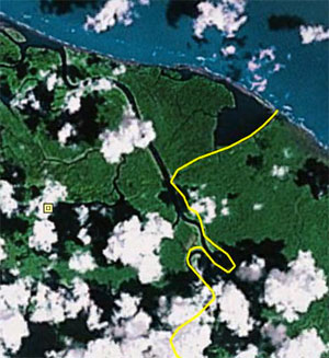
Incorrect border as shown on Google Earth.
It may not look like much, but the positioning of the yellow line above led to an embarassing international incident and what some have called an invasion. Google had the border taking a hard turn to the right and going straight to the sea when it should have gone up and around a peninsula instead.
Pity Google Maps and Google Earth, which incorrectly placed a portion of the border between Nicaragua and Costa Rica.
Details of what happened next are fuzzy. But a Nicaraguan commander, Eden Pastora, cited the glitch in Google Maps as the justification for ordering his troops across the border, where they took down a Costa Rican flag, raised a Nicaraguan flag and possibly destroyed a portion of protected rainforest.
Later, officials claimed Pastora mistakenly thought the territory belonged to Nicaragua, blaming a “bug in Google” for the mistake. (Apparently, however, both countrys’ official government survey maps and Microsoft’s Bing Maps showed the correct border.)
The search giant admitted to its 2.7 kilometer-long mistake.
In Google’s defense, both nations have long argued off-and-on about the border, which eventually led to the US government appointing an independent commissioner to survey the site and arbitrate the matter back in 1897 — one of a succession of outside arbitrators.
This time, the Organization of American States and the UN Security Council were called in to reconcile the kerfluffle.
Wired’s take on events — “Nicaraguan Invasion? Blame Google Maps” — can be found here; there is also a more in-depth website devoted to the error and the overall mapping dispute.
by Adrian Giordani & Dan Drollette
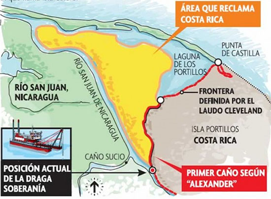
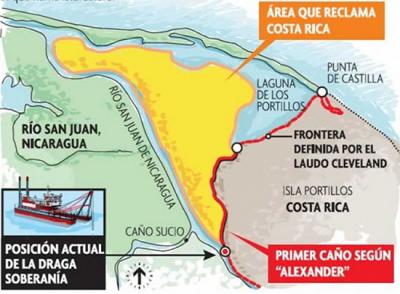
The correct border (above) includes the area in yellow as belonging to Costa Rica, according to the latest ruling from the International Court of Justice. Original infographic courtesy La Prensa
Digital Stream
-
ICYMI: #HPC resources & hi-res satellite imagery used to aid #NepalEarthquake disaster relief: http://t.co/1oFT4oRPZ9 http://t.co/uwPJt5R8rI
1 hour 36 min agovia Twitter
-
(5/5) Top five stories in #iSGTW history: #1 "Turning the microscope inwards" | http://t.co/4mugeU0vRT http://t.co/w8uKI660Ek
11 hours 2 min agovia Twitter
-
(4/5) Top five stories in #iSGTW history: #2 "CERN lends a hand" | http://t.co/k1C9a6K6uJ http://t.co/1kSJvBpNfA
11 hours 3 min agovia Twitter


Comments
Post new comment